Walking Tour 5 - Emerson-Thoreau Amble
1.7-mile (2.74-km), 40- to 60-minutes’ walking time, one-way, + sightseeing time. The trail from the Concord Independent Battery Gun House to Walden Pond is not a smooth path. It passes over tree roots, some plank-walks over mud, and it crosses the MA Route 2 highway (crosswalk with traffic-signal walk lights). There is no public transportation to or from Walden Pond. Plan your return before you begin this hike!
The Emerson – Thoreau Amble is a re-creation of the route Ralph Waldo Emerson, Henry David Thoreau, Louisa May Alcott and other Concordians may have followed on walks between their homes in Concord and Walden Pond.
Inaugurated in June 2013, the Amble begins from behind the Emerson House (which is across Cambridge Turnpike from the Concord Museum), and from the Concord Independent Battery Gun House, to the Thoreau House Site near the shore of Walden Pond.
The walk takes 40 to 60 minutes. The unpaved path is uneven in places and requires climbing some short but steepish hills. The trail may be somewhat muddy after rain (though boardwalks cover most of the wet places). Sturdy footwear is recommended.
The path may be difficult for those with mobility challenges who may wish to follow Walden Street to Walden Pond instead.
Emerson-Thoreau Amble Trailhead
Start your walk at the Concord Independent Battery Gun House at the northeast corner of Heywood Meadow (opposite 145 Lexington Road), just west of the Emerson House (28 Cambridge Turnpike).
Note that there's a public water fountain just east of the Gun House on the sidewalk to the Emerson House. The fountain operates in the warm months, usually May through September.
Also note that dogs are allowed along the Emerson-Thoreau Amble in the Hapgood Wright Town Forest on the north side of MA Route 2, but they are not allowed in Walden Pond State Reservation (that is, on the south side of MA Route 2).

The Bay Circuit Trail, a 230-mile (370-km) multi-use hiking trail around the Boston region, follows the route of the Emerson-Thoreau Amble, so you'll see markers for both trails along your way.
The first part of the trail from the Gun House is swampy, but boardwalks are provided.
The path wanders down to Concord's Mill Brook, which it crosses on a wooden footbridge, then passes over a tangle of tree roots and continues to skirt a large cultivated field to the left, plowed in spring, growing in summer, abundant in autumn, mud and stubble in winter.

Look for this trail sign and these markers.

Follow the boardwalk.

Concord Ice Company Turn
Turn left when you come to Walden Street, then left again following the sign to the Concord Ice Company. Continue straight on this unpaved road keeping the Ice Company on your left. Continue straight into the field. At its far end, watch for a marker for the left turn into the forest of lofty pines, part of the Hapgood Wright Town Forest.
The trail crosses the Mill Brook again on a wooden bridge, then through the forest of gigantic pines, finally coming to a T-intersection. Turn left to reach Fairyland Pond.

Look for these trail markers.

Continue across this field and look for a left-turn marker.
Fairyland Pond
Fairyland Pond, in Hapgood Wright Town Forest, is a favorite strolling area surrounded by well-beaten footpaths. When you reach the pond (its northern end), turn left and follow the trail around the east shore of the pond.

Fairyland Pond
At the southern end, look for the trail markers to point left (south) by a little rill. Follow the water course to the base of Brister's Hill. At the foot of a tree is Brister's Spring, the source of the rill. (You'll learn more about Brister Freeman in a few minutes.)
Climb Brister's Hill following the trail, and you'll reach Thoreau's Path on Brister's Hill.

Brister's Spring
Thoreau's Path on Brister's Hill
Walking uphill from Fairyland Pond and past Brister’s Spring, at the top of the slope you are in Walden Woods on Brister’s Hill, a small nature preserve featuring Thoreau’s Path.

In the mid-1800s, Brister Freeman, formerly enslaved, lived here free and tended fruit orchards for a living. Thoreau wrote about him in his Journal:

This land, exploited for sand and gravel mining in the mid-1900s, was in danger of large-scale commercial development. It was acquired and protected by the Walden Woods Project, which created Thoreau’s Path, a short walk through the forest past granite slabs bearing quotations from Thoreau, set in the earth.
You can wander here along Thoreau's Path, reading the inscribed granite slabs, but finally you turn right (west) and reach the entrance shown in the photo, which is on Walden Street near the intersection with MA Route 2.
Use the walk signal and pedestrian walkway to cross this busy four-lane highway. Cross carefully, and follow the Emerson – Thoreau Amble trail marks into the forest.
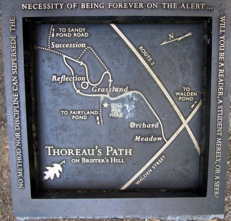
Map of Thoreau's Path on Brister's Hill.
Thoreau's Beanfield
After crossing the highway, follow the trail markers and keep your eye out on the right-hand side of the path for an inscribed granite slab marking the spot where Thoreau is thought to have cultivated his beanfield.
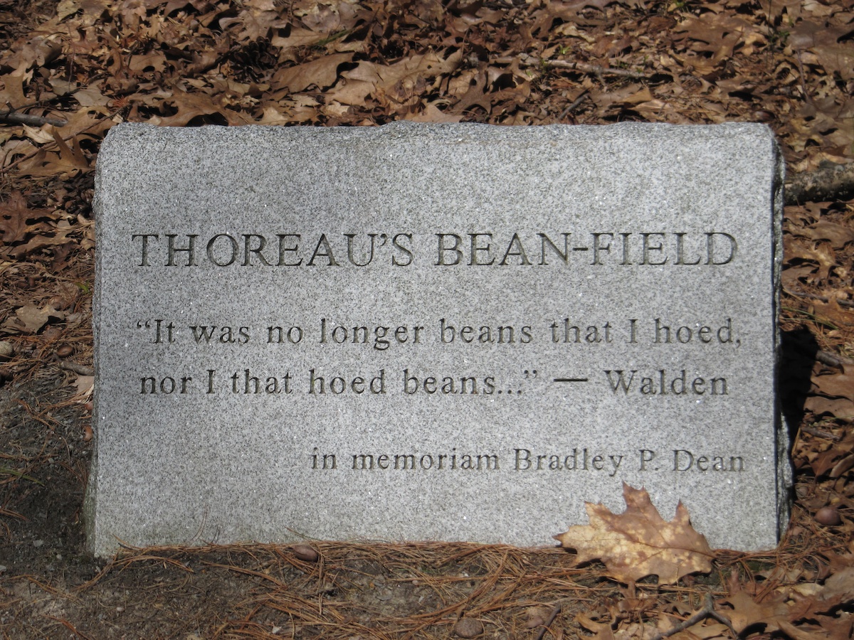
Thoreau's idea was to raise beans for food and as a cash crop for the necessities which he could not scavenge or provide for himself. As he hoed, he turned up stones, Indian arrowheads, bits of pottery and glass, all making sounds when struck by his hoe that were added to the music of the birds and the breeze in the trees. His labor became a living experience of nature, history, culture and craft: “It was no longer beans that I hoed, nor that I hoed beans…” (—from Walden).
(Bradley P Dean (1954-2006) was a Concord Thoreau scholar, writer and editor.)

Removing the weeds, putting fresh soil about the bean stems, and encouraging this weed which I had sown, making the yellow soil express its summer thought in bean leaves and blossoms rather than in wormwood and piper and millet grass, making the earth say beans instead of grass, -- this was my daily work.—Walden
Thoreau House Site
The Emerson-Thoreau Amble comes to an end at the Thoreau House Site marked by granite pillars, a stone cairn, and a wooden sign. The site is just a short stroll from the shore of Walden Pond at a place now called Thoreau's Cove.
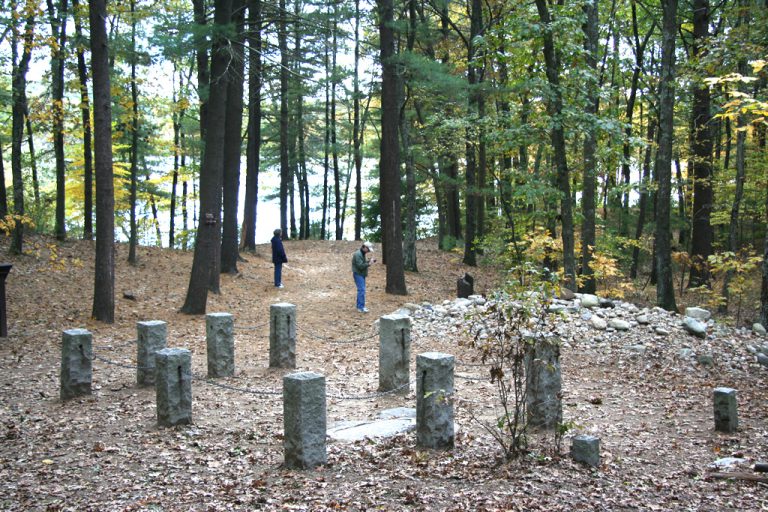
The approximate site of Thoreau’s house had been known for years. His old friend, the Concord sage Bronson Alcott (father of Louisa May Alcott) had walked out from Concord in 1872 with a visitor and placed a stone at what he remembered to be the site of Thoreau’s house.
This began the custom, and later visitors—ecological and literary pilgrims, really—also brought stones until the stones formed a substantial cairn.
Exactly a century after Thoreau built his little house and moved here, amateur archeologist Roland Wells Robbins spent three months digging the ground near the cairn until he discovered the footings for the chimney of the house.
Today an inscribed stone marks the place of the chimney, and granite standing stones frame the area the little house covered. A wooden plaque next to the cairn bears Thoreau’s most famous words:

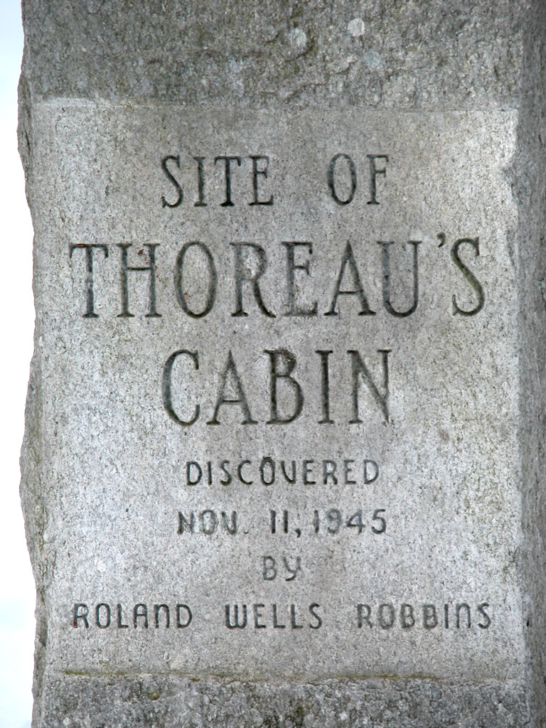
Inscription on one of the granite standing stones.
Walden Pond
The Thoreau House Site is near the northern shore of Walden Pond, closest point to the center of Concord. It's a 6/10-mile (1-km) 12-minute walk south and east along the Pond Path that follows the shore to reach Walden's swimming beach, the parking lots, and the Visitor Center (map).
